Geolocate

Lyndhurst topographic map

Click on the map to display elevation.

About this map

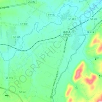
Name: Lyndhurst topographic map, elevation, terrain.

Location: Lyndhurst, Augusta County, Virginia, United States (37.98840 -78.98004 38.04949 -78.92332)

Average elevation: 1,463 ft

Minimum elevation: 1,299 ft

Maximum elevation: 2,156 ft

Augusta County trails, hiking, mountain biking, running and outdoor activities

Gear up for your next adventure:

🛏️Cold Weather Sleeping Bag - Warm sleeping bag for cold conditions
🕶️GPS Smartphone Mount - Secure mount for phone navigation
🔥Fast-Boil Camping Stoves - Efficient cooking systems for quick trail meals
🛠️Outdoor Gear Repair Kit - Essential tools to fix gear on the trail
🪶Survival Guide Book - Expert advice for emergency preparedness

As an Amazon Associate, this site earns from qualifying purchases at no extra cost to you.