Geolocate
👉 Easily get elevation data in JSON, GeoTIFF and KML formats using Elevation API
Thank you for supporting this site ❤️
Make a donation

Xenia topographic map

Click on the map to display elevation.

About this map

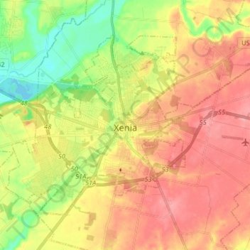
Name: Xenia topographic map, elevation, terrain.

Location: Xenia, Greene County, Ohio, 45385, United States (39.64920 -83.99302 39.72258 -83.86106)

Average elevation: 945 ft

Minimum elevation: 784 ft

Maximum elevation: 1,076 ft

Greene County trails, hiking, mountain biking, running and outdoor activities

Other topographic maps

Click on a map to view its topography, its elevation and its terrain.

Washington Mills

United States > Ohio > Greene County

Average elevation: 863 ft

John Bryan State Park

United States > Ohio > Greene County > Clifton

Average elevation: 1,014 ft

New Germany

United States > Ohio > Greene County > Beavercreek > New Germany

Average elevation: 922 ft

Wrightview

United States > Ohio > Greene County > Fairborn

Average elevation: 883 ft

Gear up for your next adventure:

🌐World Map Poster - Decorative world maps with topographic info
🔌USB Car Charger - Car charger for on‑the‑go power needs
🔪Outdoor Multitools - Essential survival tools for gear repair and field use
🧭GPS Watch Accessories - Bands and chargers for GPS watches
🪑Ultralight Camp Chairs - Portable seating for resting after a long day of mapping

As an Amazon Associate, this site earns from qualifying purchases at no extra cost to you.