
Bad Wiessee topographic map
Interactive map
Click on the map to display elevation.
About this map
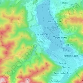
Name: Bad Wiessee topographic map, elevation, terrain.
Location: Bad Wiessee, Landkreis Miesbach, Bavaria, 83707, Germany (47.66273 11.64274 47.74813 11.74047)
Average elevation: 3,091 ft
Minimum elevation: 2,369 ft
Maximum elevation: 5,151 ft
Other topographic maps
Click on a map to view its topography, its elevation and its terrain.
Hubertus
Germany > Bavaria > Landkreis Miesbach > Kreuth
Hubertus, Kreuth, Landkreis Miesbach, Bavaria, Germany
Average elevation: 3,504 ft
Fischbachau
Germany > Bavaria > Landkreis Miesbach
Fischbachau, Landkreis Miesbach, Bavaria, 83730, Germany
Average elevation: 3,045 ft
Schliersee
Germany > Bavaria > Landkreis Miesbach
Schliersee, Landkreis Miesbach, Bavaria, 83727, Germany
Average elevation: 3,540 ft