
Make a donation
Gear up for your next adventure:
As an Amazon Associate, this site earns from qualifying purchases at no extra cost to you.
Noia topographic map
Click on the map to display elevation.
Make a donation
Gear up for your next adventure:
As an Amazon Associate, this site earns from qualifying purchases at no extra cost to you.
Noia
Dentro del término municipal de Noya existen dos zonas diferenciadas, una zona litoral de poca altitud que cubre la mayor parte del municipio y otra zona de carácter más montañoso.
Make a donation
Gear up for your next adventure:
As an Amazon Associate, this site earns from qualifying purchases at no extra cost to you.
About this map
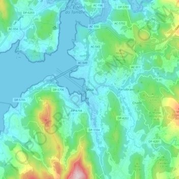
Name: Noia topographic map, elevation, terrain.
Location: Noia, Noya, La Coruña, Galicia, 15200, España (42.74508 -8.92774 42.82508 -8.84774)
Average elevation: 302 ft
Minimum elevation: -16 ft
Maximum elevation: 1,562 ft
Make a donation
Gear up for your next adventure:
As an Amazon Associate, this site earns from qualifying purchases at no extra cost to you.
Other topographic maps
Click on a map to view its topography, its elevation and its terrain.