
Thank you for supporting this site ❤️
Make a donation
Make a donation
Gear up for your next adventure:
As an Amazon Associate, this site earns from qualifying purchases at no extra cost to you.
Quebrantadero topographic map
Click on the map to display elevation.
Thank you for supporting this site ❤️
Make a donation
Make a donation
Gear up for your next adventure:
As an Amazon Associate, this site earns from qualifying purchases at no extra cost to you.
About this map
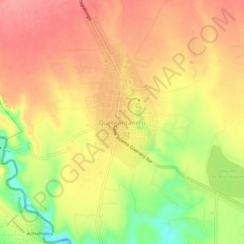
Name: Quebrantadero topographic map, elevation, terrain.
Location: Quebrantadero, Axochiapan, Morelos, Mexico (18.50206 -98.81045 18.54206 -98.77045)
Average elevation: 3,461 ft
Minimum elevation: 3,278 ft
Maximum elevation: 3,570 ft
Thank you for supporting this site ❤️
Make a donation
Make a donation
Gear up for your next adventure:
As an Amazon Associate, this site earns from qualifying purchases at no extra cost to you.