
Sewanee topographic map
Click on the map to display elevation.
Sewanee
Sewanee lies on the western edge of the Cumberland Plateau in the southeastern part of Middle Tennessee. It is located at 35°12′4″N 85°55′17″W / 35.20111°N 85.92139°W / 35.20111; -85.92139 (35.201232, -85.921524). It is at elevation 1,929 feet (588 m).
About this map
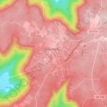
Name: Sewanee topographic map, elevation, terrain.
Average elevation: 1,768 ft
Minimum elevation: 988 ft
Maximum elevation: 2,034 ft
Franklin County trails, hiking, mountain biking, running and outdoor activities
Other topographic maps
Click on a map to view its topography, its elevation and its terrain.
Sewanee
United States > Tennessee > Franklin County > Sewanee > Saint Andrews
Average elevation: 1,880 ft