
Make a donation
Gear up for your next adventure:
As an Amazon Associate, this site earns from qualifying purchases at no extra cost to you.
Kadoma topographic map
Click on the map to display elevation.
Make a donation
Gear up for your next adventure:
As an Amazon Associate, this site earns from qualifying purchases at no extra cost to you.
Kadoma
The city is located in Kadoma District, Mashonaland West Province, one of the 10 administrative provinces in Zimbabwe. This location lies approximately 141 kilometres (88 mi), by road, southwest of Harare, the national capital and largest city in the country. The city lies on Highway A-5, between Harare and Bulawayo, approximately 300 kilometres (190 mi) northeast of Bulawayo. Kadoma is situated at an elevation of 3,881 feet (1,183 m) above sea level.
Make a donation
Gear up for your next adventure:
As an Amazon Associate, this site earns from qualifying purchases at no extra cost to you.
About this map
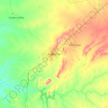
Name: Kadoma topographic map, elevation, terrain.
Location: Kadoma, Mashonaland West Province, Zimbabwe (-18.49740 29.75350 -18.17740 30.07350)
Average elevation: 3,720 ft
Minimum elevation: 3,451 ft
Maximum elevation: 4,186 ft
Make a donation
Gear up for your next adventure:
As an Amazon Associate, this site earns from qualifying purchases at no extra cost to you.
Other topographic maps
Click on a map to view its topography, its elevation and its terrain.