Geolocate

Stroud topographic map

Click on the map to display elevation.

About this map

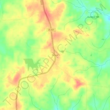
Name: Stroud topographic map, elevation, terrain.

Location: Stroud, Chambers County, Alabama, 36855, United States (33.03484 -85.35078 33.07484 -85.31078)

Average elevation: 804 ft

Minimum elevation: 696 ft

Maximum elevation: 889 ft

Chambers County trails, hiking, mountain biking, running and outdoor activities

Other topographic maps

Click on a map to view its topography, its elevation and its terrain.

Five Points

United States > Alabama > Chambers County

Average elevation: 827 ft

Cusseta

United States > Alabama > Chambers County

Average elevation: 696 ft

Valley

United States > Alabama > Chambers County

Average elevation: 627 ft

LaFayette

United States > Alabama > Chambers County

Average elevation: 791 ft

Cusseta

United States > Alabama > Chambers County

Average elevation: 696 ft

Gear up for your next adventure:

🥾Men's Hiking Boots - Durable, waterproof footwear for rugged terrain and steep inclines
🎒Trail Energy Bars - High‑calorie bars for hiking energy
🪶Trail Camera - Capture wildlife on your hikes
🗺️Topographic Maps - Detailed topo maps for hiking, exploring and outdoor navigation
🧦Hiking Socks - Comfortable socks to prevent blisters on long hikes

As an Amazon Associate, this site earns from qualifying purchases at no extra cost to you.