Geolocate

Awitan topographic map

Click on the map to display elevation.

About this map

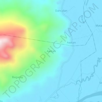
Name: Awitan topographic map, elevation, terrain.

Location: Awitan, Camarines Norte, Bicol Region, Philippines (14.19463 122.82964 14.23463 122.86964)

Average elevation: 443 ft

Minimum elevation: 0 ft

Maximum elevation: 2,362 ft

Other topographic maps

Click on a map to view its topography, its elevation and its terrain.

Daet River

Philippines > Camarines Norte > Daet > Bibirao

Average elevation: 62 ft

Daet River

Philippines > Camarines Norte > Daet

Average elevation: 10 ft

Bagasbas Beach

Philippines > Camarines Norte > Daet

Average elevation: 3 ft

Paracale

Philippines > Camarines Norte

Average elevation: 36 ft

Gear up for your next adventure:

📖Nature Tracking Books - Learn to track wildlife and terrain
🪵Folding Camp Saw - Compact saw for wood and campsite work
🥘Titanium Cookware - Durable, featherlight pots and pans for backpacking
🎒Day Hiking Backpack - Lightweight backpack perfect for day trips and outdoor adventures
🛡️Bear Spray Outdoor - Protection in bear country hikes

As an Amazon Associate, this site earns from qualifying purchases at no extra cost to you.