
Thank you for supporting this site ❤️
Make a donation
Make a donation
Gear up for your next adventure:
As an Amazon Associate, this site earns from qualifying purchases at no extra cost to you.
Pesaro e Urbino topographic map
Click on the map to display elevation.
Thank you for supporting this site ❤️
Make a donation
Make a donation
Gear up for your next adventure:
As an Amazon Associate, this site earns from qualifying purchases at no extra cost to you.
About this map
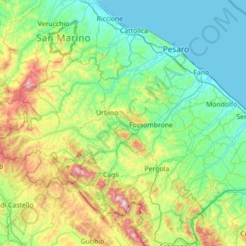
Name: Pesaro e Urbino topographic map, elevation, terrain.
Location: Pesaro e Urbino, Marche, Italy (43.41659 12.18545 43.97160 13.17231)
Average elevation: 1,086 ft
Minimum elevation: -7 ft
Maximum elevation: 5,515 ft
Thank you for supporting this site ❤️
Make a donation
Make a donation
Gear up for your next adventure:
As an Amazon Associate, this site earns from qualifying purchases at no extra cost to you.