Geolocate

Asingan topographic map

Click on the map to display elevation.

About this map

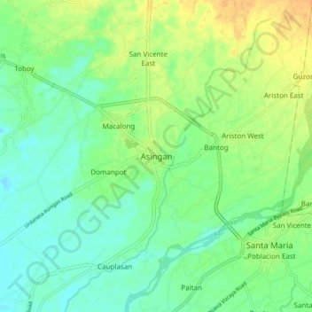
Name: Asingan topographic map, elevation, terrain.

Location: Asingan, Pangasinan, Ilocos Region, 2439, Philippines (15.96378 120.63024 16.04378 120.71024)

Average elevation: 141 ft

Minimum elevation: 102 ft

Maximum elevation: 200 ft

Other topographic maps

Click on a map to view its topography, its elevation and its terrain.

Infanta

Philippines > Pangasinan

Average elevation: 223 ft

Bugallon

Philippines > Pangasinan

Average elevation: 643 ft

Sinocalan River

Philippines > Pangasinan > Santa Barbara

Average elevation: 20 ft

Sinocalan River

Philippines > Pangasinan > San Manuel

Average elevation: 1,161 ft

Labrador

Philippines > Pangasinan

Average elevation: 148 ft

Lasud River

Philippines > Pangasinan > Abagatanen

Average elevation: 308 ft

Santiago Island

Philippines > Pangasinan > Bolinao

Average elevation: 30 ft

San Carlos

Philippines > Pangasinan

Average elevation: 26 ft

Malasiqui

Philippines > Pangasinan > Malasiqui

Average elevation: 66 ft

San Roque Dam

Philippines > Pangasinan

Average elevation: 748 ft

Siapar Island

Philippines > Pangasinan

Average elevation: 7 ft

Gear up for your next adventure:

🧭GPS Watch Accessories - Bands and chargers for GPS watches
🔊Portable Camp Speaker - Music and alerts at camp
📡Handheld GPS Device - Reliable handheld GPS for outdoor navigation
🧼Biodegradable Camping Soap - Eco‑friendly soap for outdoor hygiene
🧺Microfiber Travel Towels - Compact and fast-drying towels for trail use

As an Amazon Associate, this site earns from qualifying purchases at no extra cost to you.