
Thank you for supporting this site ❤️
Make a donation
Make a donation
Gear up for your next adventure:
As an Amazon Associate, this site earns from qualifying purchases at no extra cost to you.
Kelibia topographic map
Click on the map to display elevation.
Thank you for supporting this site ❤️
Make a donation
Make a donation
Gear up for your next adventure:
As an Amazon Associate, this site earns from qualifying purchases at no extra cost to you.
About this map
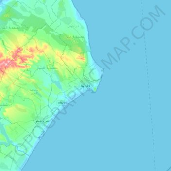
Name: Kelibia topographic map, elevation, terrain.
Location: Kelibia, قليبية الغربية, معتمدية قليبية, Nabeul, 8090, Tunisia (36.68566 10.93357 37.00566 11.25357)
Average elevation: 59 ft
Minimum elevation: -10 ft
Maximum elevation: 738 ft
Thank you for supporting this site ❤️
Make a donation
Make a donation
Gear up for your next adventure:
As an Amazon Associate, this site earns from qualifying purchases at no extra cost to you.