
Thank you for supporting this site ❤️
Make a donation
Make a donation
Gear up for your next adventure:
As an Amazon Associate, this site earns from qualifying purchases at no extra cost to you.
Auderghem - Oudergem topographic map
Click on the map to display elevation.
Thank you for supporting this site ❤️
Make a donation
Make a donation
Gear up for your next adventure:
As an Amazon Associate, this site earns from qualifying purchases at no extra cost to you.
About this map
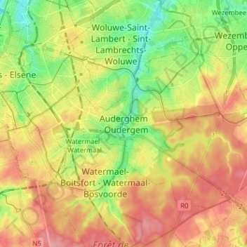
Name: Auderghem - Oudergem topographic map, elevation, terrain.
Location: Auderghem - Oudergem, Brussels-Capital, 1160, Belgium (50.77717 4.38709 50.85717 4.46709)
Average elevation: 292 ft
Minimum elevation: 121 ft
Maximum elevation: 459 ft
Thank you for supporting this site ❤️
Make a donation
Make a donation
Gear up for your next adventure:
As an Amazon Associate, this site earns from qualifying purchases at no extra cost to you.