
Make a donation
Gear up for your next adventure:
As an Amazon Associate, this site earns from qualifying purchases at no extra cost to you.
Wahlbach topographic map
Click on the map to display elevation.
Make a donation
Gear up for your next adventure:
As an Amazon Associate, this site earns from qualifying purchases at no extra cost to you.
Wahlbach
Wahlbach liegt im südlichen Siegerland. Charakteristisch für den Ort sind die für diese Region großen Haubergswälder und die die Orte umgebenden Wiesenanteile. Wahlbach ist mit 12,39 km² die flächenmäßig größte Ortschaft in der Gemeinde Burbach. Etwa 88 % (entspricht 10,9 km²) der Fläche davon sind Wald- und Wiesenanteil. Der Ort liegt etwa 1 km nordwestlich vom Burbacher Ortskern und grenzt auch an den Ort Burbach. Durch ihn fließt die Heller in Richtung Neunkirchen. Mitten im Ort trifft die Buchheller, ein kleiner Bach, der hinter Lippe am Stegskopf entspringt, auf den Fluss. Etwas weiter flussabwärts mündet des Weiteren der Gilsbach, welcher bei Gilsbach entspringt, in die Heller. Die höchste Erhebung im Ortsgebiet ist der Steincheskopf und der Schallroth im Westen mit je einer Höhe von 478 m über NN.
Make a donation
Gear up for your next adventure:
As an Amazon Associate, this site earns from qualifying purchases at no extra cost to you.
About this map
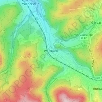
Name: Wahlbach topographic map, elevation, terrain.
Average elevation: 1,332 ft
Minimum elevation: 955 ft
Maximum elevation: 1,932 ft
Make a donation
Gear up for your next adventure:
As an Amazon Associate, this site earns from qualifying purchases at no extra cost to you.