
Make a donation
Gear up for your next adventure:
As an Amazon Associate, this site earns from qualifying purchases at no extra cost to you.
Nottingham Canal Local Nature Reserve topographic map
Click on the map to display elevation.
Make a donation
Gear up for your next adventure:
As an Amazon Associate, this site earns from qualifying purchases at no extra cost to you.
About this map
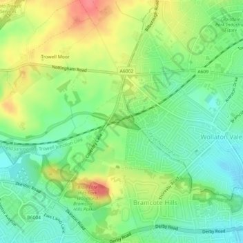
Name: Nottingham Canal Local Nature Reserve topographic map, elevation, terrain.
Average elevation: 217 ft
Minimum elevation: 128 ft
Maximum elevation: 341 ft
Make a donation
Gear up for your next adventure:
As an Amazon Associate, this site earns from qualifying purchases at no extra cost to you.
Other topographic maps
Click on a map to view its topography, its elevation and its terrain.
Make a donation
Gear up for your next adventure:
As an Amazon Associate, this site earns from qualifying purchases at no extra cost to you.
Make a donation
Gear up for your next adventure:
As an Amazon Associate, this site earns from qualifying purchases at no extra cost to you.
River Erewash
United Kingdom > England > Nottinghamshire > Broxtowe
The approximate meaning of the name is not in doubt, but there is room for debate about the precise derivation and its connotations. Brewer gives the commonly accepted explanation that it comes from the Old English words irre ("wandering") and wisce ("wet meadow"). This is accepted by Kenneth Cameron, a…
Average elevation: 285 ft
Make a donation
Gear up for your next adventure:
As an Amazon Associate, this site earns from qualifying purchases at no extra cost to you.
Make a donation
Gear up for your next adventure:
As an Amazon Associate, this site earns from qualifying purchases at no extra cost to you.