Geolocate

Penguin topographic map

Click on the map to display elevation.

About this map

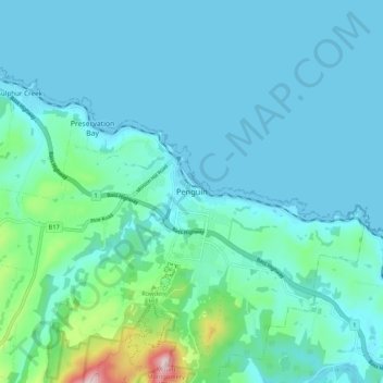
Name: Penguin topographic map, elevation, terrain.

Location: Penguin, Tasmania, 7316, Australia (-41.15510 146.03248 -41.07510 146.11248)

Average elevation: 190 ft

Minimum elevation: -3 ft

Maximum elevation: 1,460 ft

Gear up for your next adventure:

📦Gear Storage Bags - Organize and protect outdoor equipment
🧤Hiking Gloves - Protective gloves for rugged trails
🧯Emergency Survival Kit - All‑in‑one survival essentials for the backcountry
🔋Solar Power Banks - Keep your GPS and phone charged in remote wilderness areas
🗃️Trail First Aid Kit - Essential kit for outdoor injuries and emergencies

As an Amazon Associate, this site earns from qualifying purchases at no extra cost to you.