
Thank you for supporting this site ❤️
Make a donation
Make a donation
Gear up for your next adventure:
As an Amazon Associate, this site earns from qualifying purchases at no extra cost to you.
Inarawan topographic map
Click on the map to display elevation.
Thank you for supporting this site ❤️
Make a donation
Make a donation
Gear up for your next adventure:
As an Amazon Associate, this site earns from qualifying purchases at no extra cost to you.
About this map
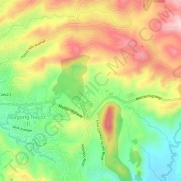
Name: Inarawan topographic map, elevation, terrain.
Location: Inarawan, Rizal, Calabarzon, 1879, Philippines (14.60552 121.18081 14.64552 121.22081)
Average elevation: 705 ft
Minimum elevation: 240 ft
Maximum elevation: 1,220 ft
Thank you for supporting this site ❤️
Make a donation
Make a donation
Gear up for your next adventure:
As an Amazon Associate, this site earns from qualifying purchases at no extra cost to you.