Geolocate

Logroño topographic map

Click on the map to display elevation.

About this map
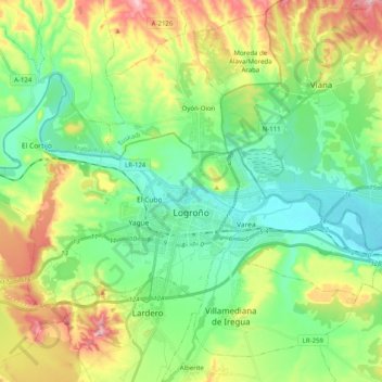
Name: Logroño topographic map, elevation, terrain.

Location: Logroño, Rioja, Spain (42.42885 -2.54227 42.51992 -2.34197)

Average elevation: 1,470 ft

Minimum elevation: 1,155 ft

Maximum elevation: 2,119 ft

Other topographic maps

Click on a map to view its topography, its elevation and its terrain.
Logroño

Spain > Rioja > Logroño

Average elevation: 1,942 ft

Rave

Spain > Rioja > Villalba de Rioja

Average elevation: 2,290 ft

Ciriñuela

Spain > Rioja > Cirueña

Average elevation: 2,297 ft

Arroyo Frio

Spain > Rioja > Viniegra de Arriba

Average elevation: 4,747 ft

Arroyo Frio

Spain > Rioja > Viniegra de Arriba

Average elevation: 4,747 ft

Cueva de los cien pilares

Spain > Rioja > Arnedo

Average elevation: 1,880 ft

Rastro la Cueva

Spain > Rioja > Lagunilla del Jubera

Average elevation: 1,621 ft

La Unión de los Tres Ejércitos

Spain > Rioja > Clavijo

Average elevation: 2,133 ft

Gear up for your next adventure:

📻Weather Alert Radios - Stay informed of storm risks while off-the-grid
🛰️Handheld GPS Units - Professional satellite navigators for precise backcountry mapping
🧭Compass with Lanyard - Easy‑carry compass for navigation
🗺️NatGeo Topo Maps - High-quality waterproof printed topographic maps of US Parks
🔦Compact Flashlight - Reliable flashlight for emergencies

As an Amazon Associate, this site earns from qualifying purchases at no extra cost to you.