Geolocate

Logroño topographic map

Click on the map to display elevation.

About this map

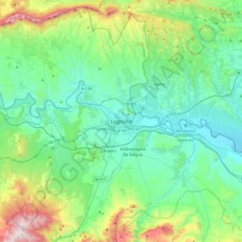
Name: Logroño topographic map, elevation, terrain.

Location: Logroño, Rioja, 26003, Spain (42.30612 -2.59967 42.62612 -2.27967)

Average elevation: 1,942 ft

Minimum elevation: 1,089 ft

Maximum elevation: 4,905 ft

Gear up for your next adventure:

📦Gear Storage Bags - Organize and protect outdoor equipment
🛡️Insect Repellent - Protection against bugs during outdoor activities
🎒Gear Packing Cubes - Organize your backpack efficiently
🔭Compact Binoculars - HD vision for scouting terrain and identifying distant landmarks
🧷Carabiner Set - Durable clips for gear attachment

As an Amazon Associate, this site earns from qualifying purchases at no extra cost to you.