Geolocate

Haidt topographic map

Click on the map to display elevation.

About this map

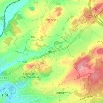
Name: Haidt topographic map, elevation, terrain.

Location: Haidt, Hof, Bayern, 95028, Deutschland (50.31883 11.92633 50.35883 11.96633)

Average elevation: 1,729 ft

Minimum elevation: 1,549 ft

Maximum elevation: 1,946 ft

Gear up for your next adventure:

📶Vehicle Signal Boosters - Improve reception in rural areas while driving to trailheads
🧷Carabiner Set - Durable clips for gear attachment
💧Water Purification System - Clean water on the trail with reliable purifiers
🏥Hiking First Aid Kits - Comprehensive medical kits for remote trail injuries
🎒Gear Packing Cubes - Organize your backpack efficiently

As an Amazon Associate, this site earns from qualifying purchases at no extra cost to you.