
Make a donation
Gear up for your next adventure:
As an Amazon Associate, this site earns from qualifying purchases at no extra cost to you.
Bommern topographic map
Click on the map to display elevation.
Make a donation
Gear up for your next adventure:
As an Amazon Associate, this site earns from qualifying purchases at no extra cost to you.
Bommern
Das S-Bahnzielnetz 2015 hatte ursprünglich vorgesehen, in Fahrtrichtung Witten hinter dem Haltepunkt Wetter (Ruhr) eine Ausfädelung zu bauen, damit die S-Bahnen auf der anderen Ruhrseite die reaktivierten Haltepunkte Wetter-Wengern Ost und Witten-Bommern Höhe bedienen. Wetter (Ruhr) wäre damit zum Knotenbahnhof geworden. Nach dem Amtsantritt Oliver Wittkes 2005 wurden allerdings sämtliche Zielvereinbarungen einer Neubewertung unterzogen. Die notwendige neue Ruhrbrücke wurde abgelehnt, sodass die S-Bahn ihren Weg nicht ändern wird.
Make a donation
Gear up for your next adventure:
As an Amazon Associate, this site earns from qualifying purchases at no extra cost to you.
About this map
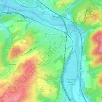
Name: Bommern topographic map, elevation, terrain.
Average elevation: 410 ft
Minimum elevation: 246 ft
Maximum elevation: 702 ft
Make a donation
Gear up for your next adventure:
As an Amazon Associate, this site earns from qualifying purchases at no extra cost to you.
Other topographic maps
Click on a map to view its topography, its elevation and its terrain.
Make a donation
Gear up for your next adventure:
As an Amazon Associate, this site earns from qualifying purchases at no extra cost to you.