
Tabuk topographic map
Click on the map to display elevation.
About this map
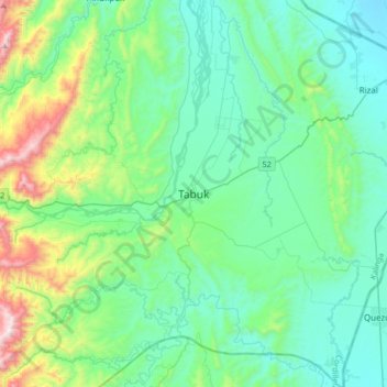
Name: Tabuk topographic map, elevation, terrain.
Average elevation: 906 ft
Minimum elevation: 144 ft
Maximum elevation: 4,006 ft
Other topographic maps
Click on a map to view its topography, its elevation and its terrain.
Chico River
The Chico River, has a total length of 233 kilometres (145 mi), making it the longest tributary of the Cagayan River, itself the largest river in the Philippines. For centuries it has been central to farming, trading, livelihoods, and daily life, whether as a benefit or hindrance. It provided a source of water…
Average elevation: 1,919 ft