
Make a donation
Gear up for your next adventure:
As an Amazon Associate, this site earns from qualifying purchases at no extra cost to you.
Saint Paul topographic map
Click on the map to display elevation.
Make a donation
Gear up for your next adventure:
As an Amazon Associate, this site earns from qualifying purchases at no extra cost to you.
Saint Paul
The year 1858 saw more than 1,000 steamboats service Saint Paul, making it a gateway for settlers to the Minnesota frontier or Dakota Territory. Geography was a primary reason the city became a transportation hub. The location was the last good point to land riverboats coming upriver due to the river valley's topography. For a time, Saint Paul was called "The Last City of the East." Fort Snelling was important to St. Paul from the start. Direct access from St. Paul did not happen until the 7th bridge was built in 1880. Before that, there was a cable ferry crossing dating to at latest the 1840s. Once streetcars appeared, a new bridge to St. Paul was built in 1904. Until the town built its first jail the fort's brig served St. Paul.
Make a donation
Gear up for your next adventure:
As an Amazon Associate, this site earns from qualifying purchases at no extra cost to you.
About this map
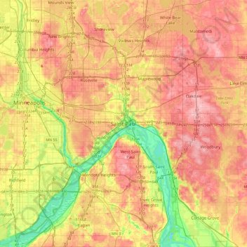
Name: Saint Paul topographic map, elevation, terrain.
Location: Saint Paul, Ramsey County, Minnesota, 55101, United States (44.78975 -93.25310 45.10975 -92.93310)
Average elevation: 896 ft
Minimum elevation: 653 ft
Maximum elevation: 1,099 ft
Ramsey County trails, hiking, mountain biking, running and outdoor activities
Make a donation
Gear up for your next adventure:
As an Amazon Associate, this site earns from qualifying purchases at no extra cost to you.
Other topographic maps
Click on a map to view its topography, its elevation and its terrain.
South Saint Anthony Park
United States > Minnesota > Ramsey County > Saint Paul
Average elevation: 886 ft
Make a donation
Gear up for your next adventure:
As an Amazon Associate, this site earns from qualifying purchases at no extra cost to you.