
Make a donation
Gear up for your next adventure:
As an Amazon Associate, this site earns from qualifying purchases at no extra cost to you.
Albaicín topographic map
Click on the map to display elevation.
Make a donation
Gear up for your next adventure:
As an Amazon Associate, this site earns from qualifying purchases at no extra cost to you.
Albaicín
El Albaicín o Albayzín es un barrio del este de la ciudad española de Granada, en la comunidad autónoma de Andalucía. Está situado a una altitud de 700 a 800 m sobre el nivel del mar.
Make a donation
Gear up for your next adventure:
As an Amazon Associate, this site earns from qualifying purchases at no extra cost to you.
About this map
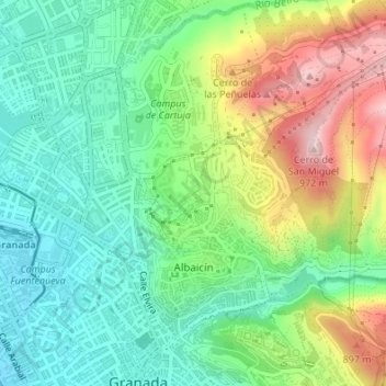
Name: Albaicín topographic map, elevation, terrain.
Average elevation: 2,510 ft
Minimum elevation: 2,156 ft
Maximum elevation: 3,166 ft
Make a donation
Gear up for your next adventure:
As an Amazon Associate, this site earns from qualifying purchases at no extra cost to you.
Other topographic maps
Click on a map to view its topography, its elevation and its terrain.
Mirador de San Miguel Alto
España > Andalucía > Comarca de la Vega de Granada > Granada
Average elevation: 2,631 ft
Silla del Moro
España > Andalucía > Comarca de la Vega de Granada > Granada
Average elevation: 2,605 ft
Mirador de la Placeta de los Carvajales
España > Andalucía > Comarca de la Vega de Granada > Granada
Average elevation: 2,438 ft
Make a donation
Gear up for your next adventure:
As an Amazon Associate, this site earns from qualifying purchases at no extra cost to you.
Dehesa del Generalife
España > Andalucía > Comarca de la Vega de Granada > Granada
Average elevation: 2,776 ft
Cerro del Sol
España > Andalucía > Comarca de la Vega de Granada > Granada
Average elevation: 2,805 ft
Mirador de San Nicolás
España > Andalucía > Comarca de la Vega de Granada > Granada
Average elevation: 2,493 ft
Lancha del Genil
España > Andalucía > Comarca de la Vega de Granada > Granada
Average elevation: 2,703 ft
Make a donation
Gear up for your next adventure:
As an Amazon Associate, this site earns from qualifying purchases at no extra cost to you.