Geolocate

Lakeland topographic map

Click on the map to display elevation.

About this map

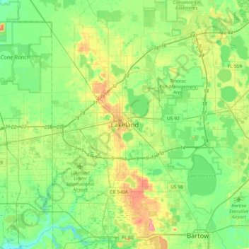
Name: Lakeland topographic map, elevation, terrain.

Location: Lakeland, Polk County, Florida, 33081, United States (27.87947 -82.10980 28.19947 -81.78980)

Average elevation: 138 ft

Minimum elevation: 46 ft

Maximum elevation: 338 ft

Polk County trails, hiking, mountain biking, running and outdoor activities

Other topographic maps

Click on a map to view its topography, its elevation and its terrain.

Dobbins Park

United States > Florida > Polk County > Lakeland

Average elevation: 190 ft

Medulla

United States > Florida > Polk County > Lakeland

Average elevation: 141 ft

Gear up for your next adventure:

📷Action Camera - Capture your outdoor adventures in HD
📌Outdoor GPS Map App - Apps and devices for digital topographic navigation
🛶Inflatable Kayak - Portable kayak for rivers, lakes, and expeditions
🧭Hiking Compass - Precision compass for reliable navigation in the wilderness
🧤Tactile Hiking Gloves - Keep hands warm while operating GPS and smartphone screens

As an Amazon Associate, this site earns from qualifying purchases at no extra cost to you.