
Make a donation
Gear up for your next adventure:
As an Amazon Associate, this site earns from qualifying purchases at no extra cost to you.
Swords Round Tower topographic map
Click on the map to display elevation.
Make a donation
Gear up for your next adventure:
As an Amazon Associate, this site earns from qualifying purchases at no extra cost to you.
About this map
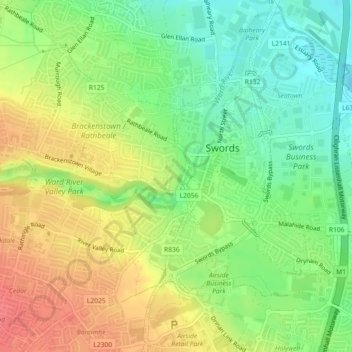
Name: Swords Round Tower topographic map, elevation, terrain.
Average elevation: 92 ft
Minimum elevation: 0 ft
Maximum elevation: 194 ft
Make a donation
Gear up for your next adventure:
As an Amazon Associate, this site earns from qualifying purchases at no extra cost to you.
Other topographic maps
Click on a map to view its topography, its elevation and its terrain.
Swords
Ireland > County Dublin > Swords
The medieval town developed in a linear pattern along Main Street, in a roughly north-south direction. Swords has one of the best examples of this settlement pattern in the Dublin region. The round tower, 26m in height, is also an indicator of early Christian settlement. The Irish high king Brian Boru is said…
Average elevation: 92 ft