
Myrtle Beach topographic map
Click on the map to display elevation.
About this map
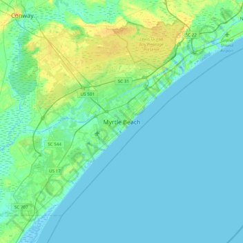
Name: Myrtle Beach topographic map, elevation, terrain.
Location: Myrtle Beach, Horry County, South Carolina, United States (33.53565 -79.05004 33.85565 -78.73004)
Average elevation: 13 ft
Minimum elevation: -16 ft
Maximum elevation: 56 ft
Horry County trails, hiking, mountain biking, running and outdoor activities
Other topographic maps
Click on a map to view its topography, its elevation and its terrain.