
Lennestadt topographic map
Interactive map
Click on the map to display elevation.
About this map
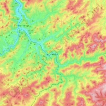
Name: Lennestadt topographic map, elevation, terrain.
Location: Lennestadt, Kreis Olpe, Noordrijn-Westfalen, 57368, Duitsland (51.05652 7.95807 51.19599 8.24149)
Average elevation: 1,385 ft
Minimum elevation: 725 ft
Maximum elevation: 2,329 ft
Other topographic maps
Click on a map to view its topography, its elevation and its terrain.
Wenden
Duitsland > Noordrijn-Westfalen > Kreis Olpe
Wenden, Kreis Olpe, Noordrijn-Westfalen, 57482, Duitsland
Average elevation: 1,309 ft
Bieberg
Duitsland > Noordrijn-Westfalen > Kreis Olpe > Wenden
Bieberg, Wenden, Kreis Olpe, Noordrijn-Westfalen, 57482, Duitsland
Average elevation: 1,243 ft
Atta-Höhle
Duitsland > Noordrijn-Westfalen > Kreis Olpe > Attendorn
Atta-Höhle, Finnentroper Straße, Attendorn, Kreis Olpe, Noordrijn-Westfalen, 57439, Duitsland
Average elevation: 1,024 ft
Schliprüthen
Duitsland > Noordrijn-Westfalen > Kreis Olpe > Finnentrop
Schliprüthen, Finnentrop, Kreis Olpe, Noordrijn-Westfalen, 57413, Duitsland
Average elevation: 1,549 ft
Hollberg
Duitsland > Noordrijn-Westfalen > Kreis Olpe > Lennestadt
Hollberg, Lennestadt, Kreis Olpe, Noordrijn-Westfalen, 57368, Duitsland
Average elevation: 1,066 ft
Kruberg
Duitsland > Noordrijn-Westfalen > Kreis Olpe > Olpe
Kruberg, Olpe, Kreis Olpe, Noordrijn-Westfalen, Duitsland
Average elevation: 1,444 ft
Drolshagen
Duitsland > Noordrijn-Westfalen > Kreis Olpe > Drolshagen
Drolshagen, Kreis Olpe, Noordrijn-Westfalen, 57489, Duitsland
Average elevation: 1,299 ft
Biggesee
Duitsland > Noordrijn-Westfalen > Kreis Olpe > Olpe > Sondern
Biggesee, Sondern, Olpe, Kreis Olpe, Noordrijn-Westfalen, Duitsland
Average elevation: 1,270 ft
Rührberg
Duitsland > Noordrijn-Westfalen > Kreis Olpe > Finnentrop
Rührberg, Finnentrop, Kreis Olpe, Noordrijn-Westfalen, Duitsland
Average elevation: 1,503 ft
Finnentrop
Duitsland > Noordrijn-Westfalen > Kreis Olpe
Finnentrop, Kreis Olpe, Noordrijn-Westfalen, 57413, Duitsland
Average elevation: 1,247 ft
Attendorn
Duitsland > Noordrijn-Westfalen > Kreis Olpe
Attendorn, Kreis Olpe, Noordrijn-Westfalen, 57439, Duitsland
Average elevation: 1,260 ft
Kirchhundem
Duitsland > Noordrijn-Westfalen > Kreis Olpe
Kirchhundem, Kreis Olpe, Noordrijn-Westfalen, 57399, Duitsland
Average elevation: 1,516 ft
Olpe
Duitsland > Noordrijn-Westfalen > Kreis Olpe
Olpe, Kreis Olpe, Noordrijn-Westfalen, 57462, Duitsland
Average elevation: 1,312 ft