
Thank you for supporting this site ❤️
Make a donation
Make a donation
Gear up for your next adventure:
As an Amazon Associate, this site earns from qualifying purchases at no extra cost to you.
Hyrum topographic map
Click on the map to display elevation.
Thank you for supporting this site ❤️
Make a donation
Make a donation
Gear up for your next adventure:
As an Amazon Associate, this site earns from qualifying purchases at no extra cost to you.
About this map
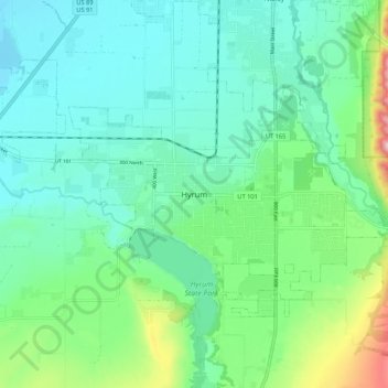
Name: Hyrum topographic map, elevation, terrain.
Location: Hyrum, Cache County, Utah, 84319-1660, United States (41.59412 -111.89519 41.67412 -111.81519)
Average elevation: 4,721 ft
Minimum elevation: 4,442 ft
Maximum elevation: 5,669 ft
Cache County trails, hiking, mountain biking, running and outdoor activities
Thank you for supporting this site ❤️
Make a donation
Make a donation
Gear up for your next adventure:
As an Amazon Associate, this site earns from qualifying purchases at no extra cost to you.