Geolocate

Pollachi topographic map

Click on the map to display elevation.

About this map

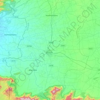
Name: Pollachi topographic map, elevation, terrain.

Location: Pollachi, Coimbatore District, Tamil Nadu, India (10.45160 76.81083 10.88900 77.18172)

Average elevation: 1,099 ft

Minimum elevation: 390 ft

Maximum elevation: 4,616 ft

Other topographic maps

Click on a map to view its topography, its elevation and its terrain.

Arasur

India > Tamil Nadu > Pollachi

Average elevation: 948 ft

Kottur

India > Tamil Nadu > Pollachi

Average elevation: 971 ft

Gear up for your next adventure:

🧭GPS Watch Accessories - Bands and chargers for GPS watches
👟Trail Running Shoes - Lightweight shoes for trail runners
🧣Hiking Neck Gaiter - Multi‑use neck protection for outdoor weather
🧭Orienteering Set - Complete compass and map reading kit
🔌Solar Panel Charger - Charge gear sustainably outdoors

As an Amazon Associate, this site earns from qualifying purchases at no extra cost to you.