Geolocate

Centro topographic map

Click on the map to display elevation.

About this map

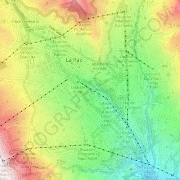
Name: Centro topographic map, elevation, terrain.

Location: Centro, La Paz, Pedro Domingo Murillo, La Paz, Bolivia (-16.52266 -68.14484 -16.48218 -68.11479)

Average elevation: 12,028 ft

Minimum elevation: 11,007 ft

Maximum elevation: 13,350 ft

Other topographic maps

Click on a map to view its topography, its elevation and its terrain.

La Paz

Bolivia > La Paz > Pedro Domingo Murillo > La Paz

The city, in west-central Bolivia 68 km (42 mi) southeast of Lake Titicaca, is set in a canyon created by the Choqueyapu River. It is in a bowl-like depression, part of the Amazon basin, surrounded by the high mountains of the Altiplano. Overlooking the city is the towering, triple-peaked Illimani. Its peaks…

Average elevation: 13,409 ft

Plaza Abaroa

Bolivia > La Paz > Pedro Domingo Murillo > La Paz

Average elevation: 11,732 ft

Laguna Charquini

Bolivia > La Paz > Pedro Domingo Murillo > La Paz

Average elevation: 16,427 ft

Cerro Charkini

Bolivia > La Paz > Pedro Domingo Murillo > La Paz

Average elevation: 16,352 ft

Glaciar Charquini

Bolivia > La Paz > Pedro Domingo Murillo > La Paz

Average elevation: 16,430 ft

Gear up for your next adventure:

🪄Magnetic Compass - Accurate compass for navigation
🧭Outdoor Navigation Book - Learn advanced navigation skills
🛠️Outdoor Gear Repair Kit - Essential tools to fix gear on the trail
🔋Solar Power Banks - Keep your GPS and phone charged in remote wilderness areas
🔊Portable Camp Speaker - Music and alerts at camp

As an Amazon Associate, this site earns from qualifying purchases at no extra cost to you.