
Ambon Island topographic map
Interactive map
Click on the map to display elevation.
About this map
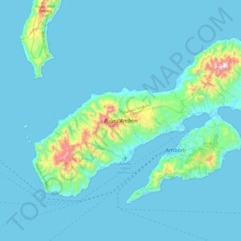
Name: Ambon Island topographic map, elevation, terrain.
Location: Ambon Island, Ambon, Moluccas, Indonesia (-3.79435 127.91691 -3.49018 128.35749)
Average elevation: 259 ft
Minimum elevation: 0 ft
Maximum elevation: 3,205 ft
Other topographic maps
Click on a map to view its topography, its elevation and its terrain.
Kel Karang Panjang
Indonesia > Moluccas > Ambon > Kel Karang Panjang
Kel Karang Panjang, Ambon, Moluccas, 97124, Indonesia
Average elevation: 151 ft