Geolocate

Newtown topographic map

Click on the map to display elevation.

About this map

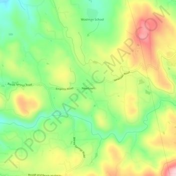
Name: Newtown topographic map, elevation, terrain.

Location: Newtown, Nevada County, California, United States (39.23267 -121.12329 39.27267 -121.08329)

Average elevation: 2,205 ft

Minimum elevation: 1,850 ft

Maximum elevation: 2,644 ft

Nevada County trails, hiking, mountain biking, running and outdoor activities

Gear up for your next adventure:

🗺️Topographic Maps - Detailed topo maps for hiking, exploring and outdoor navigation
🎒Waterproof Dry Bags - Keep your electronics and maps dry inside your pack
🪶Wildlife Field Guides - Learn animal tracking and species ID
🧯Emergency Survival Kit - All‑in‑one survival essentials for the backcountry
🌧️Backpack Rain Cover - Keep gear dry in wet weather

As an Amazon Associate, this site earns from qualifying purchases at no extra cost to you.