
Make a donation
Gear up for your next adventure:
As an Amazon Associate, this site earns from qualifying purchases at no extra cost to you.
North Fair Oaks topographic map
Click on the map to display elevation.
Make a donation
Gear up for your next adventure:
As an Amazon Associate, this site earns from qualifying purchases at no extra cost to you.
About this map
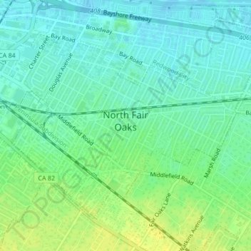
Name: North Fair Oaks topographic map, elevation, terrain.
Average elevation: 26 ft
Minimum elevation: -3 ft
Maximum elevation: 59 ft
San Mateo County trails, hiking, mountain biking, running and outdoor activities
Make a donation
Gear up for your next adventure:
As an Amazon Associate, this site earns from qualifying purchases at no extra cost to you.
Other topographic maps
Click on a map to view its topography, its elevation and its terrain.
Make a donation
Gear up for your next adventure:
As an Amazon Associate, this site earns from qualifying purchases at no extra cost to you.
Highlands
United States > California > San Mateo County > San Mateo Highlands
Average elevation: 423 ft
Make a donation
Gear up for your next adventure:
As an Amazon Associate, this site earns from qualifying purchases at no extra cost to you.
Upper Crystal Springs Reservoir
United States > California > San Mateo County
Average elevation: 394 ft
Pacifica
United States > California > San Mateo County > Pacifica > Pacifica
Average elevation: 305 ft
Make a donation
Gear up for your next adventure:
As an Amazon Associate, this site earns from qualifying purchases at no extra cost to you.
San Carlos
United States > California > San Mateo County > San Carlos > San Carlos
Average elevation: 154 ft
Burlingame
United States > California > San Mateo County > Burlingame > Burlingame
Average elevation: 184 ft
Make a donation
Gear up for your next adventure:
As an Amazon Associate, this site earns from qualifying purchases at no extra cost to you.
Pillar Point Harbor
United States > California > San Mateo County > El Granada
Average elevation: 43 ft
Half Moon Bay
United States > California > San Mateo County > Half Moon Bay > Half Moon Bay
Average elevation: 240 ft
Coyote Point Recreation Area
United States > California > San Mateo County > San Mateo
Average elevation: 3 ft
Westborough
United States > California > San Mateo County > South San Francisco
Average elevation: 394 ft
Make a donation
Gear up for your next adventure:
As an Amazon Associate, this site earns from qualifying purchases at no extra cost to you.