
Thank you for supporting this site ❤️
Make a donation
Make a donation
Gear up for your next adventure:
As an Amazon Associate, this site earns from qualifying purchases at no extra cost to you.
Buckman topographic map
Click on the map to display elevation.
Thank you for supporting this site ❤️
Make a donation
Make a donation
Gear up for your next adventure:
As an Amazon Associate, this site earns from qualifying purchases at no extra cost to you.
About this map
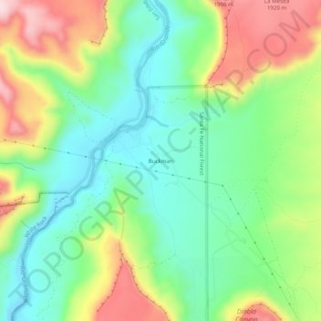
Name: Buckman topographic map, elevation, terrain.
Location: Buckman, Santa Fe County, New Mexico, 87547, United States (35.81212 -106.17732 35.85212 -106.13732)
Average elevation: 5,804 ft
Minimum elevation: 5,433 ft
Maximum elevation: 6,417 ft
Santa Fe County trails, hiking, mountain biking, running and outdoor activities
Thank you for supporting this site ❤️
Make a donation
Make a donation
Gear up for your next adventure:
As an Amazon Associate, this site earns from qualifying purchases at no extra cost to you.