
Florence topographic map
Click on the map to display elevation.
About this map
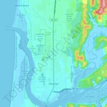
Name: Florence topographic map, elevation, terrain.
Location: Florence, Lane County, Oregon, 97439, United States (43.96413 -124.13343 44.03715 -124.07913)
Average elevation: 72 ft
Minimum elevation: -20 ft
Maximum elevation: 666 ft
Lane County trails, hiking, mountain biking, running and outdoor activities
Other topographic maps
Click on a map to view its topography, its elevation and its terrain.
Thurston Hills Natural Area
United States > Oregon > Lane County > Springfield
Average elevation: 1,063 ft