Geolocate

Dej topographic map

Click on the map to display elevation.

About this map

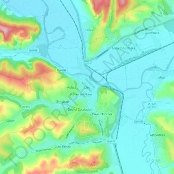
Name: Dej topographic map, elevation, terrain.

Location: Dej, Cluj, 407166, Romania (47.10267 23.83599 47.18267 23.91599)

Average elevation: 922 ft

Minimum elevation: 741 ft

Maximum elevation: 1,532 ft

Gear up for your next adventure:

🪶LED Camping Lantern - Bright lantern for camp lighting
💧Water Filtration Bottles - Safely drink from streams and lakes while exploring
🧯Portable Fire Pit - Compact fire pit for camping spots
🦶Hiking Gaiters - Keep debris and water out of your boots
🧭Orienteering Set - Complete compass and map reading kit

As an Amazon Associate, this site earns from qualifying purchases at no extra cost to you.