Geolocate

Beckley topographic map

Click on the map to display elevation.

About this map

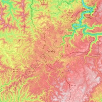
Name: Beckley topographic map, elevation, terrain.

Location: Beckley, Raleigh County, West Virginia, 25801, United States (37.61817 -81.34816 37.93817 -81.02816)

Average elevation: 2,313 ft

Minimum elevation: 1,043 ft

Maximum elevation: 3,274 ft

Raleigh County trails, hiking, mountain biking, running and outdoor activities

Other topographic maps

Click on a map to view its topography, its elevation and its terrain.

Piney Creek

United States > West Virginia > Raleigh County > Beckley

Average elevation: 2,379 ft

Gear up for your next adventure:

🪶Camp Gear Gift Set - Perfect gift bundle for outdoor fans
📌Outdoor GPS Map App - Apps and devices for digital topographic navigation
📦Dry Bags Set - Waterproof storage for electronics and clothes
🦟Ultrasonic Repellers - Create a bug-free zone at your camp or rest stop
🔭Stargazing Telescopes - Perfect for camping in low-light pollution areas shown on maps

As an Amazon Associate, this site earns from qualifying purchases at no extra cost to you.