
Thank you for supporting this site ❤️
Make a donation
Make a donation
Gear up for your next adventure:
As an Amazon Associate, this site earns from qualifying purchases at no extra cost to you.
Inverlochy topographic map
Click on the map to display elevation.
Thank you for supporting this site ❤️
Make a donation
Make a donation
Gear up for your next adventure:
As an Amazon Associate, this site earns from qualifying purchases at no extra cost to you.
About this map
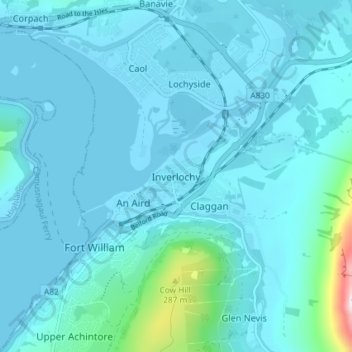
Name: Inverlochy topographic map, elevation, terrain.
Location: Inverlochy, Highland, Scotland, PH33 6NB, United Kingdom (56.80589 -5.11405 56.84589 -5.07405)
Average elevation: 157 ft
Minimum elevation: -13 ft
Maximum elevation: 1,844 ft
Thank you for supporting this site ❤️
Make a donation
Make a donation
Gear up for your next adventure:
As an Amazon Associate, this site earns from qualifying purchases at no extra cost to you.