
Thank you for supporting this site ❤️
Make a donation
Make a donation
Gear up for your next adventure:
As an Amazon Associate, this site earns from qualifying purchases at no extra cost to you.
Kakajjo topographic map
Click on the map to display elevation.
Thank you for supporting this site ❤️
Make a donation
Make a donation
Gear up for your next adventure:
As an Amazon Associate, this site earns from qualifying purchases at no extra cost to you.
About this map
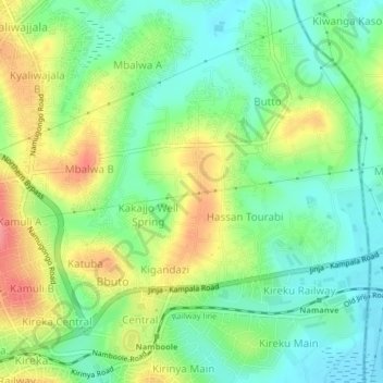
Name: Kakajjo topographic map, elevation, terrain.
Location: Kakajjo, Wakiso, Central Region, 7086, Uganda (0.34281 32.64516 0.38281 32.68516)
Average elevation: 3,835 ft
Minimum elevation: 3,727 ft
Maximum elevation: 4,003 ft
Thank you for supporting this site ❤️
Make a donation
Make a donation
Gear up for your next adventure:
As an Amazon Associate, this site earns from qualifying purchases at no extra cost to you.