
Thank you for supporting this site ❤️
Make a donation
Make a donation
Gear up for your next adventure:
As an Amazon Associate, this site earns from qualifying purchases at no extra cost to you.
Serzedelo topographic map
Click on the map to display elevation.
Thank you for supporting this site ❤️
Make a donation
Make a donation
Gear up for your next adventure:
As an Amazon Associate, this site earns from qualifying purchases at no extra cost to you.
About this map
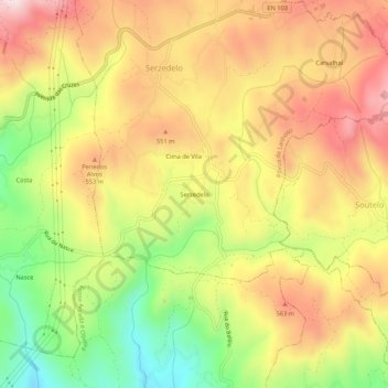
Name: Serzedelo topographic map, elevation, terrain.
Location: Serzedelo, Póvoa de Lanhoso, Braga, 4850-503, Portugal (41.58483 -8.23815 41.62483 -8.19815)
Average elevation: 1,493 ft
Minimum elevation: 712 ft
Maximum elevation: 2,165 ft
Thank you for supporting this site ❤️
Make a donation
Make a donation
Gear up for your next adventure:
As an Amazon Associate, this site earns from qualifying purchases at no extra cost to you.