
Make a donation
Gear up for your next adventure:
As an Amazon Associate, this site earns from qualifying purchases at no extra cost to you.
Requião topographic map
Click on the map to display elevation.
Make a donation
Gear up for your next adventure:
As an Amazon Associate, this site earns from qualifying purchases at no extra cost to you.
Requião
O topónimo é, certamente, de origem germânica. No entanto, a história deste território remonta a um povoamento castrejo, como demonstra o castro existente na Colina de Santa Cristina, a 300 metros de altitude.
Make a donation
Gear up for your next adventure:
As an Amazon Associate, this site earns from qualifying purchases at no extra cost to you.
About this map
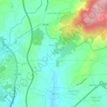
Name: Requião topographic map, elevation, terrain.
Location: Requião, Vila Nova de Famalicão, Braga, Portugal (41.39868 -8.50284 41.42596 -8.45383)
Average elevation: 449 ft
Minimum elevation: 210 ft
Maximum elevation: 1,089 ft
Make a donation
Gear up for your next adventure:
As an Amazon Associate, this site earns from qualifying purchases at no extra cost to you.
Other topographic maps
Click on a map to view its topography, its elevation and its terrain.