
Make a donation
Gear up for your next adventure:
As an Amazon Associate, this site earns from qualifying purchases at no extra cost to you.
Pussemange topographic map
Click on the map to display elevation.
Make a donation
Gear up for your next adventure:
As an Amazon Associate, this site earns from qualifying purchases at no extra cost to you.
About this map
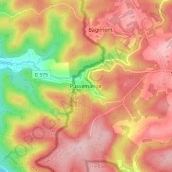
Name: Pussemange topographic map, elevation, terrain.
Average elevation: 1,070 ft
Minimum elevation: 656 ft
Maximum elevation: 1,325 ft
Make a donation
Gear up for your next adventure:
As an Amazon Associate, this site earns from qualifying purchases at no extra cost to you.
Other topographic maps
Click on a map to view its topography, its elevation and its terrain.
Hastière
Hastière is een gemeente in de provincie Namen in België. De gemeente ligt aan de Maas en telt ruim 6.000 inwoners. Hastière ligt op een hoogte van 216 meter. De vroegste delen van de abdij Hastière, die gesticht werd door paltsgraaf Wigerik van Lotharingen, dateren uit de 10e eeuw. De abdij is genoemd…
Average elevation: 669 ft
Make a donation
Gear up for your next adventure:
As an Amazon Associate, this site earns from qualifying purchases at no extra cost to you.