
Make a donation
Gear up for your next adventure:
As an Amazon Associate, this site earns from qualifying purchases at no extra cost to you.
South Yuyanq’ Ch’ex topographic map
Click on the map to display elevation.
Make a donation
Gear up for your next adventure:
As an Amazon Associate, this site earns from qualifying purchases at no extra cost to you.
About this map
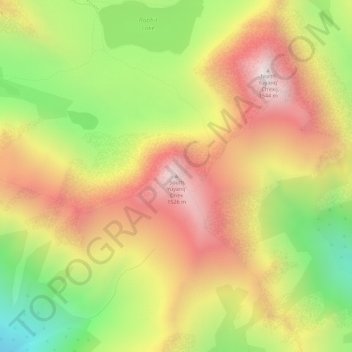
Name: South Yuyanq’ Ch’ex topographic map, elevation, terrain.
Location: South Yuyanq’ Ch’ex, Anchorage, Alaska, United States (61.02936 -149.57535 61.02946 -149.57525)
Average elevation: 3,514 ft
Minimum elevation: 1,798 ft
Maximum elevation: 5,075 ft
Anchorage trails, hiking, mountain biking, running and outdoor activities
Make a donation
Gear up for your next adventure:
As an Amazon Associate, this site earns from qualifying purchases at no extra cost to you.
Other topographic maps
Click on a map to view its topography, its elevation and its terrain.
Make a donation
Gear up for your next adventure:
As an Amazon Associate, this site earns from qualifying purchases at no extra cost to you.