Geolocate

Naujan topographic map

Click on the map to display elevation.

About this map

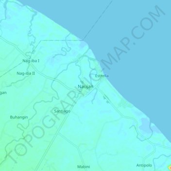
Name: Naujan topographic map, elevation, terrain.

Location: Naujan, Oriental Mindoro, Mimaropa, 5204, Philippines (13.28424 121.26307 13.36424 121.34307)

Average elevation: 13 ft

Minimum elevation: -13 ft

Maximum elevation: 171 ft

Other topographic maps

Click on a map to view its topography, its elevation and its terrain.

Inclanay Dam

Philippines > Oriental Mindoro > Inclanay > Pansulan

Average elevation: 95 ft

Bansud River

Philippines > Oriental Mindoro > Conrazon

Average elevation: 1,132 ft

Bongabong River

Philippines > Oriental Mindoro

Average elevation: 1,972 ft

Naujan Lake

Philippines > Oriental Mindoro > Malabo

Average elevation: 151 ft

Masipit

Philippines > Oriental Mindoro > Calapan

Average elevation: 13 ft

Tawiran

Philippines > Oriental Mindoro > Calapan

Average elevation: 20 ft

Lalud

Philippines > Oriental Mindoro > Calapan > Guinobatan

Average elevation: 26 ft

Gear up for your next adventure:

🪑Portable Camp Table - Compact table for campsite meals
🏥Hiking First Aid Kits - Comprehensive medical kits for remote trail injuries
🧯Emergency Survival Kit - All‑in‑one survival essentials for the backcountry
🧯Portable Fire Pit - Compact fire pit for camping spots
⛑️Personal Locator Beacon - Safety beacon for emergencies

As an Amazon Associate, this site earns from qualifying purchases at no extra cost to you.