
Obock District topographic map
Interactive map
Click on the map to display elevation.
About this map
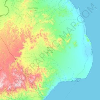
Name: Obock District topographic map, elevation, terrain.
Location: Obock District, Obock, Djibouti (11.83009 42.81077 12.51802 43.41762)
Average elevation: 1,007 ft
Minimum elevation: -3 ft
Maximum elevation: 4,518 ft
Other topographic maps
Click on a map to view its topography, its elevation and its terrain.
Rahra
Djibouti > Obock > Obock District
Rahra, Obock District, Obock, Djibouti
Average elevation: 2,464 ft