
Make a donation
Gear up for your next adventure:
As an Amazon Associate, this site earns from qualifying purchases at no extra cost to you.
Astrakhan District topographic map
Click on the map to display elevation.
Make a donation
Gear up for your next adventure:
As an Amazon Associate, this site earns from qualifying purchases at no extra cost to you.
About this map
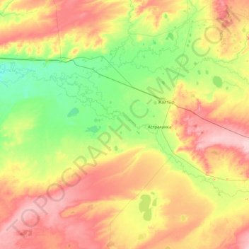
Name: Astrakhan District topographic map, elevation, terrain.
Location: Astrakhan District, Akmola Region, Kazakhstan (51.03471 68.92461 52.03475 70.44459)
Average elevation: 1,060 ft
Minimum elevation: 896 ft
Maximum elevation: 1,339 ft
Make a donation
Gear up for your next adventure:
As an Amazon Associate, this site earns from qualifying purchases at no extra cost to you.
Other topographic maps
Click on a map to view its topography, its elevation and its terrain.
Kokshetau
It was the administrative center of Kokshetau Region (oblast) from 1944 to 1991 as part of the Soviet Union and from 1991 as part of Kazakhstan to 1997 when it was abolished. It is also situated at the junction of the Trans-Kazakhstan and South Siberian railways. Kokshetau lies at an elevation of approximately…
Average elevation: 814 ft
Qorğaljın
Kazakhstan > Akmola Region > Qorğaljın district
The village is located on the Kazakh Uplands. The average altitude in the village is about 330 meters above sea level. The terrain is a continuous plain with small hills and water areas.
Average elevation: 1,083 ft
Make a donation
Gear up for your next adventure:
As an Amazon Associate, this site earns from qualifying purchases at no extra cost to you.