
Mount Elliott topographic map
Interactive map
Click on the map to display elevation.
About this map
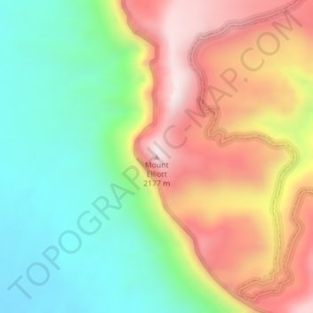
Name: Mount Elliott topographic map, elevation, terrain.
Location: Mount Elliott, Emery County, Utah, USA (39.18283 -110.30027 39.18293 -110.30017)
Average elevation: 5,846 ft
Minimum elevation: 4,879 ft
Maximum elevation: 7,060 ft
Other topographic maps
Click on a map to view its topography, its elevation and its terrain.
Canyonlands National Park - Maze District
Canyonlands National Park - Maze District, White Rim Road, San Juan County, Utah, USA
Average elevation: 5,072 ft
Long Valley Junction
USA > Utah > Long Valley Junction
Long Valley Junction, Kane County, Utah, 84710, USA
Average elevation: 7,530 ft
Thousand Lake Mountain
Thousand Lake Mountain, Wayne County, Utah, USA
Average elevation: 10,961 ft
Haystack Lake
Haystack Lake, Lakes Country Trail, Summit County, Utah, USA
Average elevation: 10,062 ft
Capitol Hill
USA > Utah > Salt Lake City
Capitol Hill, Salt Lake City, Salt Lake County, Utah, 84103, USA
Average elevation: 4,954 ft
La Sal Mountains Viewpoint
La Sal Mountains Viewpoint, Arches Entrance Road, Grand County, Utah, 84532-2134, USA
Average elevation: 4,419 ft
Browns Park
Browns Park, Bountiful, Davis County, Utah, 84010, USA
Average elevation: 5,105 ft
Timpanogos Glacier
USA > Utah > Aspen Grove
Timpanogos Glacier, Mount Timpanogos Trail #052, Aspen Grove, Utah County, Utah, USA
Average elevation: 10,328 ft
Gladys Lake
Gladys Lake, Head of Rock Creek Trail, Duchesne County, Utah, USA
Average elevation: 11,106 ft
Little Bear River
Little Bear River, Cache County, Utah, 84319, USA
Average elevation: 4,839 ft
San Juan River
San Juan River, San Juan County, Utah, 84717, USA
Average elevation: 6,453 ft
Canyonlands National Park
Canyonlands National Park, Wayne County, Utah, USA
Average elevation: 5,381 ft