Geolocate

Pontypridd topographic map

Click on the map to display elevation.

About this map

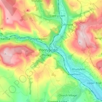
Name: Pontypridd topographic map, elevation, terrain.

Location: Pontypridd, Rhondda Cynon Taf, Wales, CF, United Kingdom (51.56010 -3.38494 51.64010 -3.30494)

Average elevation: 604 ft

Minimum elevation: 121 ft

Maximum elevation: 1,247 ft

Gear up for your next adventure:

🛰️Handheld GPS Units - Professional satellite navigators for precise backcountry mapping
🏔️Mountain Trail Maps - High‑detail maps for popular peaks
🎒Outdoor Daypacks - Lightweight backpacks designed for carrying maps and essential gear
🦶Hiking Gaiters - Keep debris and water out of your boots
🥩Freeze-Dried Meals - Nutritious and lightweight food for remote expeditions

As an Amazon Associate, this site earns from qualifying purchases at no extra cost to you.