Geolocate

Graham topographic map

Click on the map to display elevation.

About this map

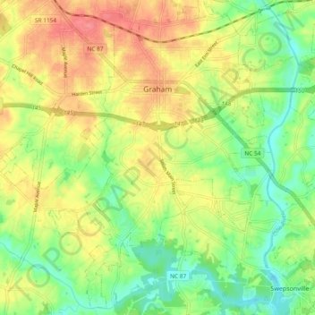
Name: Graham topographic map, elevation, terrain.

Location: Graham, Alamance County, North Carolina, 27352, United States (36.01642 -79.43280 36.08871 -79.33954)

Average elevation: 571 ft

Minimum elevation: 459 ft

Maximum elevation: 692 ft

Alamance County trails, hiking, mountain biking, running and outdoor activities

Other topographic maps

Click on a map to view its topography, its elevation and its terrain.

Snow Camp

United States > North Carolina > Alamance County

Average elevation: 607 ft

Glencoe

United States > North Carolina > Alamance County

Average elevation: 604 ft

Elon

United States > North Carolina > Alamance County > Elon

Average elevation: 659 ft

Gear up for your next adventure:

🥾Men's Hiking Boots - Durable, waterproof footwear for rugged terrain and steep inclines
☀️Outdoor Sunscreen - High protection sunscreen for outdoor activities
🔭Stargazing Telescopes - Perfect for camping in low-light pollution areas shown on maps
🧭GPS Watch Accessories - Bands and chargers for GPS watches
🏥Hiking First Aid Kits - Comprehensive medical kits for remote trail injuries

As an Amazon Associate, this site earns from qualifying purchases at no extra cost to you.